|
Walk: Half-way House to
Turf-cutters Hut near Black Rock Mountain
BACK
|
|
 |
|
|
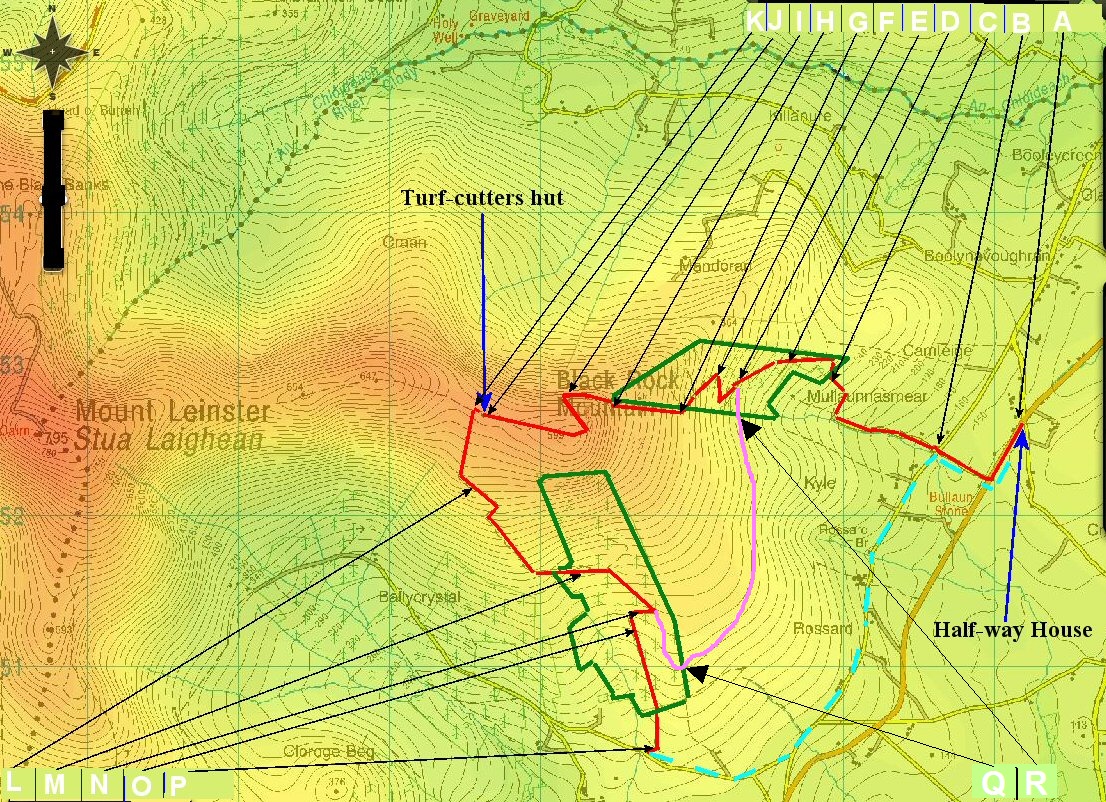
This walk starts about 5Km SW of Bunclody on the
R746. Red lines are the walking route.
|
|
| A=52.617362,-6.684415
Half Way House B=52.6163200,-6.6926120 Enter Mullawn Lane C=52.6209648,-6.7028999 Enter Forrest D=52.6218082,-6.7066049 Keep straight on E=52.6207282,-6.7112783 Keep Straight on F=52.6211299,-6.7135683 Keep left G=52.6189082,-6.7170466 Enter fire break H=52.6192132,-6.7239283 Top of Forrest. Follow path quarter way round north side of Blackrock mountain I=52.6197998,-6.7290216 Make you way to the top of Blackrock from here on a faintly defined path. You could just head straight up to the top from "H", but it is a bit easier this way. Note: there is a false path continuing west from I. This used to be a way of avoiding the top of Black Rock, but is too low on the ridge and eventually peters out as people find that it is going nowhere. If you want to avoid the summit, head WSW from I to pick up the path to the hut. J=52.6187366, -6.7366765 Turf-cutters Hut K=52.6191291, -6.7376704 Start of Turf-cutters road, just west of the hut. L=52.6143898, -6.7372533 Coming down turf-cutters road. M=52.6096732, -6.7265899 Enter Wood N=52.6069248, -6.7223266 Keep on this gravel road. O=52.6060432, -6.7225749 Keep on this gravel road. P=52.5987265, -6.7207387 Exit onto tarmac road. Q=52.604918, -6.718076 Wood/Moorland crossing. R=52.618484, -6.712383 Gate dividing woodland and moorland. Red line equals a 2 or 2.5 hour walk. Dotted Blue line = about 4.5Km Pink line is 1.6 Km. Blackrock Mountain is 599 Metres high. Mount Leinster is 795 Metres |
This walk
uses only public right of way. It takes about 2 or 2.5 hours to
cover the red line on the map. There is limited parking at points B
and P, if you wanted to shorten the walk. When I last did this walk,
we left one car at P and one at B. The dotted blue line is about 4.5
Km and is along small tarmac roads and is a nice walk in its own
right. Point A is a car park at the Half-way house Shop/Pub/Service station. Not a bad sort place to finish any walk :). *This is also an excellent way of climbing Mount Leinster with a well defined path continuing west from K. Otherwise you could walk up the TV transmitter road from 52.636813,-6.793857. This walk takes between 45 and 60 minutes to the top. I have put GPS coordinates at places on the map where there might be confusion about which direction to take. The areas enclosed by green lines are the woods that you will pass through. There are other woods in the area which can be seen by looking in detail at the map. Bear in mind that trees get cut down and planted and these woods may change, however the GPS coordinates will not change. From early on you can see the sea on the south and east coasts. Bring a map showing areas including the S/E coasts and Mount Leinster and with the aid of a compass you can identify features such as the Saltee Islands. Enjoy your walk and as always take proper precautions e.g. mobile phone, clothing and footwear. See some photos of the walk >>> |
|
If you find any mistakes, please email me so that I can make corrections email BACK |
|